
Union Minister Dr Jitendra Singh inaugurated India’s first ‘SkyCast’ System at Indira Gandhi International (IGI) Airport, New Delhi on 29 May 2026.
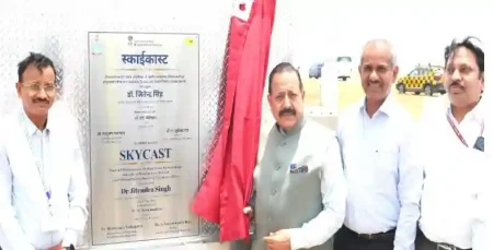
Union Minister of State (Independent Charge) for Science & Technology, Earth Sciences, MoS PMO, Personnel, Public Grievances, Pensions, Atomic Energy and Space, Dr. Jitendra Singh inaugurated the SkyCast System and Fog Observatory facility at Glide Path 10, calling it the beginning of a new era in Indian aviation.
Union Minister Dr Jitendra Singh spoke about India’s first ‘SkyCast’ System.
» So far, only 18 such advanced systems exist worldwide. India has now become the 19th in the world to install this integrated atmospheric remote sensing system for aviation weather monitoring.
- After IGI Airport Delhi, the second such facility will come up at Jewar Airport, followed by expansion to other airports across India.
SkyCast will bring a major transformation in aviation safety by providing real-time information to pilots and aviation operators during critical weather situations.
Developed by:
» The scientific foundation of SkyCast comes from the Winter Fog Experiment (WiFEX), jointly initiated by IITM and IMD under the Ministry of Earth Sciences at IGI Airport in 2015.
- WiFEX generated critical understanding of fog formation, aerosol-cloud interaction, visibility reduction and urban boundary-layer processes, which contributed to the development of this next-generation operational system.
The Indian Institute of Tropical Meteorology (IITM) and the India Meteorological Department (IMD) are premier research and operational institutions under India’s Ministry of Earth Sciences (MoES).
The SkyCast System under Mission Mausam reflects India’s commitment towards building weather-smart infrastructure, strengthening aviation resilience and ensuring safer and more reliable services through scientific innovation.
About India’s First 'SkyCast' System:
» SkyCast is one of the biggest landmarks in India’s aviation history as it combines multiple atmospheric observation technologies for fog monitoring, turbulence detection and high-impact weather forecasting.
- The system integrates state-of-the-art atmospheric remote sensing technologies, including Radar Wind Profiler, SODAR, Microwave Radiometer, Ground-based Fog Aerosol Spectrometer (GFAS) and CL61 Lidar-based Ceilometer to provide comprehensive real-time atmospheric intelligence.
- The facility will strengthen monitoring and warning capabilities across runways, making take-offs and landings safer.
Radar Wind Profiler:
The core of SkyCast is an advanced boundary layer Radar Wind Profiler, which continuously measures wind speed, wind direction, turbulence, vertical velocity and boundary-layer dynamics up to nearly 3 kilometres above the airport. These parameters are crucial during aircraft descent and landing operations, where precise atmospheric information helps improve safety.
Ground-based Fog Aerosol Spectrometer:
The SkyCast facility also includes advanced fog monitoring instruments such as the Ground-based Fog Aerosol Spectrometer (GFAS), which provides detailed information on fog droplets, aerosols and aerosol-fog interactions.
CL61 Lidar-based Ceilometer:
The system also integrates the CL61 Lidar-based Ceilometer, which continuously monitors the vertical structure of fog. This helps understand fog formation, visibility reduction and atmospheric conditions affecting aviation operations.
Significance:
- SkyCast brings together real-time measurements of fog, aerosols, turbulence, moisture, visibility and atmospheric conditions into a single advanced aviation weather intelligence framework.
- The system will support pilots, airlines, airport operators and air traffic management agencies with accurate nowcasting and early warning services.
- Beyond aviation, SkyCast observations will support advanced forecasting models, artificial intelligence-enabled decision support systems, urban weather forecasting, pollution management, transport advisories and disaster preparedness initiatives.